Pages

Showing posts with label Te Ara. Show all posts

Monday, 25 November 2013

Using Te Ara 3

Using Te Ara -
The Encyclopedia of New Zealand
3. Manukau Harbour

L.I. Develop our knowledge of Auckland and the Tamaki river
Familiarise ourselves with an online NZ encyclopaedia

Use this link to open Te Ara
Enter Tamaki river into the search box and use the Harbours and wetlands page to answer these questions.

What two adjectives are used to describe the Manukau Harbour?
It is wide and shallow

What landforms are common in the harbour?
Wetlands and Rivers

What two things about the Manukau Harbour have led to shipwrecks?
Its entrance is prone to swells and shifting sandbars – the cause of many shipwrecks.

What was the worst shipwreck on the Manukau bar?
On a fine day on 7 February 1863 the HMS Orpheus – carrying naval stores – approached Manukau Harbour. Seeing it was off course to cross the bar, the onshore signalman motioned to change direction. But the warning was too late, and the ship ran aground. As the sea got heavier, it began to break up. Lifeboats were swamped. With the crew clinging helplessly to the rigging, the ship’s masts fell one by one into the sea. Of the 259 people on board, 189 drowned. It remains New Zealand’s worst maritime disaster.

Monday, 21 October 2013

Library Skills - Using Te Ara 2

Using Te Ara -
The Encyclopedia of New Zealand
2. Tamaki River

L.I.    Develop our knowledge of Auckland and the Tamaki river
    Familiarise ourselves with an online NZ encyclopaedia

Use this link to open Te Ara
Enter Tamaki river into the search box and use the Eastern suburbs: Oraki  to the Tamaki estuary page to answer these questions.

Where does the river flow from and to?
River flowing from Māngere East to a tidal estuary on the Waitematā
What was the link used by Maori called?
It was a vital link (by way of the Ōtāhuhu portage) to the Manukau for Māori

What two bodies of water does it join?
The two bodies that deportage is the Manukau Harbour and the Waitemata Harbour

What sort of landform is Tāhuna Tōrea?
Tāhuna Tōrea is a sandspit, reaching across towards Buckland’s Beach,

What is the name of the marina on the Tamaki river?
Half Moon Bay Marina is on the eastern shore of the Tamaki River

When was the first Panmure Bridge built?
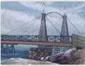
The first Panmure Bridge was built to span the Tāmaki River in 1866,

When was the current bridge built?
The current bridge was built in 1959.